
From Inspiration Point to Garden of the Gods
The 160-mile River to River Trail spans the Mississippi and the Ohio as well as some of the state’s most stunning scenery
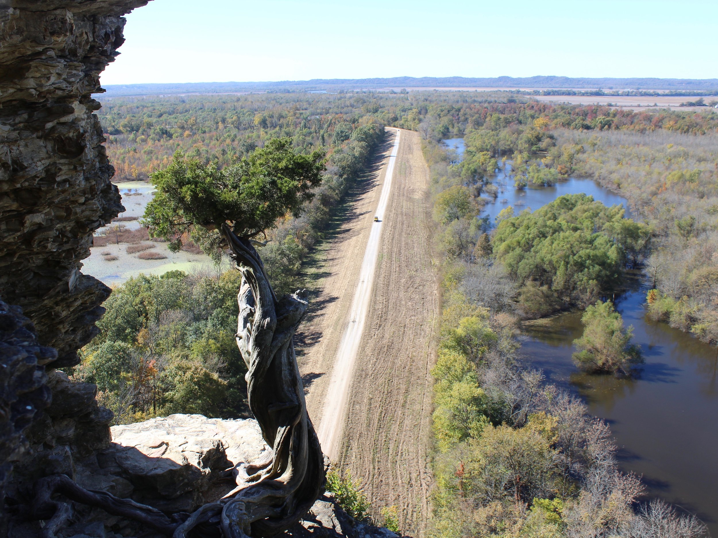
Inspiration Point, looking down on the Big Muddy River, is toward the western end of the River to River Trail. (One Illinois/Ted Cox)
By Ted Cox
Could there be a connection between Inspiration Point and Garden of the Gods?
Not a spiritual connection, mind you, but a real trail through the Shawnee National Forest connecting two of the most stunning natural sites in southern Illinois.
News broke earlier this month that Paducah, Ky., was moving on a long-proposed Tennessee River-Line Trail, plotted for 652 miles running into Tennessee. So why can’t Illinois do something like that? Do Tennessee and Kentucky have a monopoly on natural beauty?
Turns out they’re actually mimicking Illinois, which has a 160-mile River to River Trail arcing across the state’s southern tip from the Ohio River to the Mississippi, from Elizabethtown to Grand Tower.
The original trail, laid out by the Civilian Conservation Corps during the Great Depression in the ‘30s, actually ran pretty east-west, starting at Battery Rock further up the Ohio. “It was mainly a route over country roads used some by horses, but it was neglected and basically abandoned and had been forgotten about, although there were still some Forest Service maps that showed it,” said Gillum Ferguson, of the River to River Trail Society.
In the ‘70s and ‘80s “some interest revived,” Ferguson added. Legendary Southern Illinois University President Delyte Morris “was a big exponent of the trail and actually put together a projected map across the state, but it was never actually realized.”
It wasn’t until the 1990s that John O’Dell, a former school superintendent who’d taken a role in Salinas County tourism, carried it out. “He got out his topographic maps, put on his boots, and went out and marked the trail,” Ferguson said. “He pushed it through.”
Along the way he formed the River to River Trail Society as “a vehicle for promoting and maintaining the trail,” Ferguson said. According to Ferguson, it has about 300 members on a closed Facebook page, and draws about three dozen people to its annual meeting, set for June 1 this year in Harrisburg, where Ferguson resides.
The society sponsors hikes along the trail in the spring and fall, from March into May and October through November, due to what Ferguson called a “bifurcated tourism season.”
“Typically, spring and fall are very nice times to be here,” he said. “July, August — hot, humid, ticks, snakes, you name it. Only the hardiest go in and the best prepared. There are ways to deal with all of these things, but they require some advanced planning.”
Otherwise, though, the trail is not intimidating, although Ferguson granted that parts of it can be “a slog,” adding, “If you’re talking about doing the entire trail as a through hike, I would say it is not probably for novice hikers, but there are many, many sections where novice hikers will be comfortable.”
According to Ferguson, the whole 160-mile trail is typically done in 10 days to two weeks by an average hiker — camping along the way, of course — although it’s been done in four days by a trail runner. “There is a fair amount of up and down,” he said. Although the like-minded Shawnee Trails Conservancy caters to those on horseback, and there are state horse camps along the way, Ferguson said, “I think more people do the entire trail on foot than on horseback. There are logistical difficulties doing it on horseback.”
Either way, though, it’s an Illinois few state residents would immediately recognize.
“In places, it’s stunning,” Ferguson said. “There is a good deal of variety, but the chief glory of this area are what we call the hills and hollers, but especially the limestone bluffs, which give rise to all kinds of wonderful views. People comment all the time when they’re here that they can’t believe they’re in Illinois.”
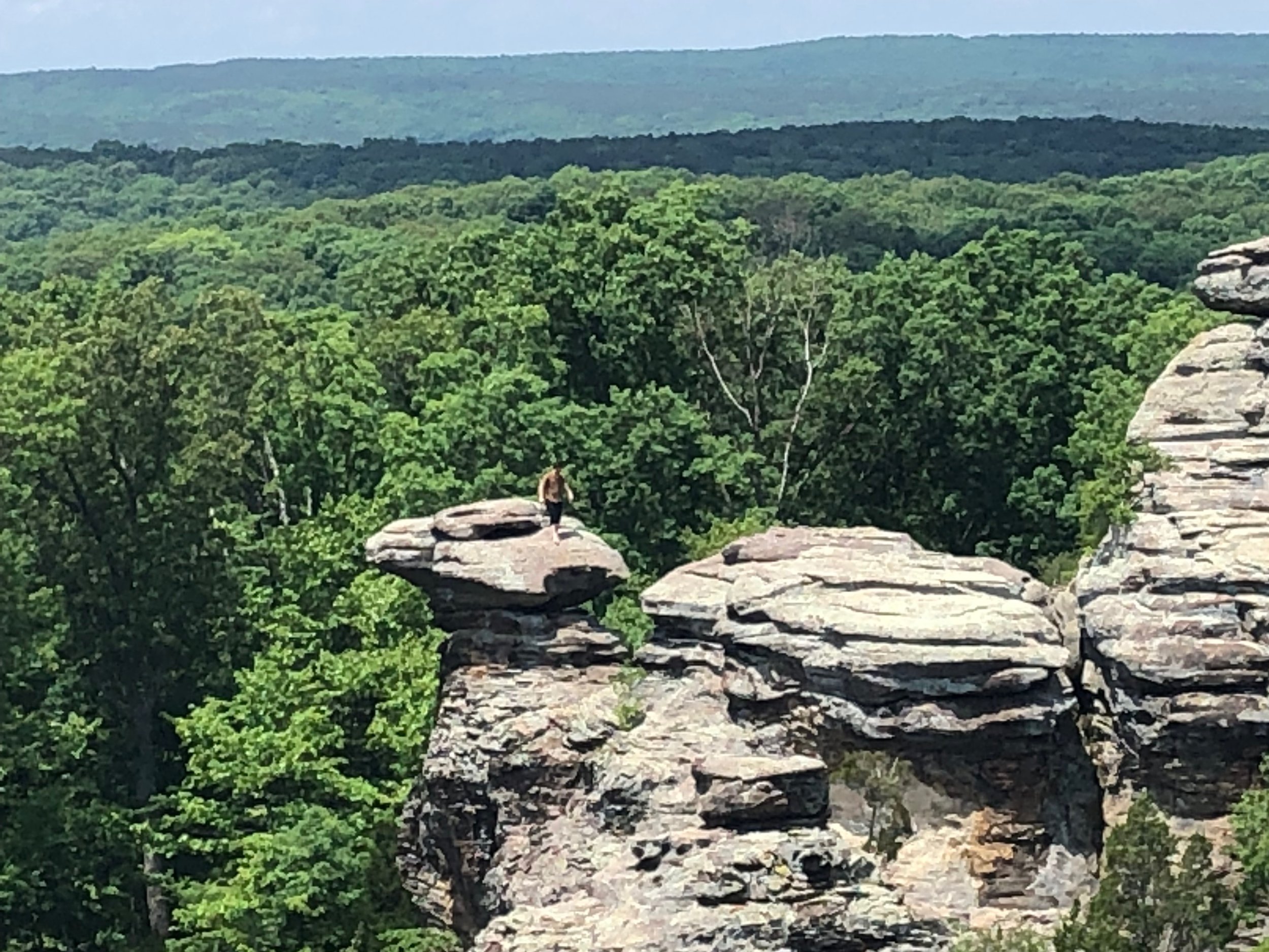
A daring sightseer scales Camel Rock at Garden of the Gods. (One Illinois/Ted Cox)
Those limestone bluffs include Garden of the Gods, near Herod near where the trail turns west, and Inspiration Point and Tower Rock at the western end. In between are wilderness areas such as Lusk Creek and Panther Den, as well as Garden of the Gods. (Although it has limestone formations like Camel Rock, unlike other sites dubbed Garden of the Gods it was named for the lushness of the forest surroundings.) Along the way there are also Trail of Tears State Park and Giant City State Park, among others.
The sheer expanse created problems with the trail’s establishment. “One of the chronic issues with the trail is there’s a multitude of landowners,” Ferguson said. Primarily, the land belongs to the U.S. Forest Service through the Shawnee National Forest, which likewise is bifurcated in sections to the east and west, but other segments are owned by the U.S. Fish and Wildlife Service, Illinois through its state parks, SIU, and some private property, “with the permission of the landowners of course,” Ferguson added.
“In terms of a master plan for the trail, it’s always been difficult to implement,” he said. Those various entities often altered the trail, without informing anyone else or shifting the signs along the way. Although they moved away from wooden signs, which tended to decay after a few years, to plastic signs, the Forest Service still insists on wooden signs in the designated wilderness areas.
“They’re easy to miss unless you know where they are,” Ferguson said, “which of course is contrary to the idea.”
Yet all those groups now get together quarterly, including the River to River Trail Society and the Shawnee Trails Conservancy, to share information and coordinate plans. “We found that we all get along pretty well,” Ferguson said. There’s also a formal map posted online and updated regularly. “It’s in a lot better shape than it was five years ago,” he added.
The biggest change was adopted about a decade ago, when the eastern end was shifted from Battery Rock down the Ohio River to Elizabethtown. “The problem with Battery Rock is it’s very isolated, there are no services there, no parking,” Ferguson said. “It’s difficult to find and very easy to get lost on the way there. And once you’re there it’s not all that easy to find your way out.
“It’s not the middle of nowhere,” he added, “but if you get on top of that rock you can see the middle of nowhere.”
Eliizabethtown, or “E-Town” as the locals call it, by contrast has bed & breakfasts, restaurants, and convenience stores. “It is really a better place to spend the night and head out in the morning,” Ferguson said, and “takes you almost immediately into the woods.” Sticklers can still follow the map on the eastern leg to Battery Rock if they insist on leaving behind some of the most glorious landscape Illinois has to offer and instead approaching the middle of nowhere.
